 david coombe history
Background and links: the maps in the S.T. Gill project, covering his period in South Australia and up to his early Victorian gold diggings works. Also included are some more general reference maps for 1840s South Australia.
In this article ...
S.T. Gill pictured many scenes that can be geographically located. Place and time supply context to a picture. This in turn can allow us to identify additional features – buildings, landmarks or even people – further enhancing context. Clearly it helps to use contemporary maps to locate the scenes, but later images, even photographs, can also help.
This project includes two types of interactive online maps:
Click the link to jump to the map of interest or just scroll down.
STATUS: I consider these maps are largely complete. Feedback, including on viewpoint locations, is welcome.
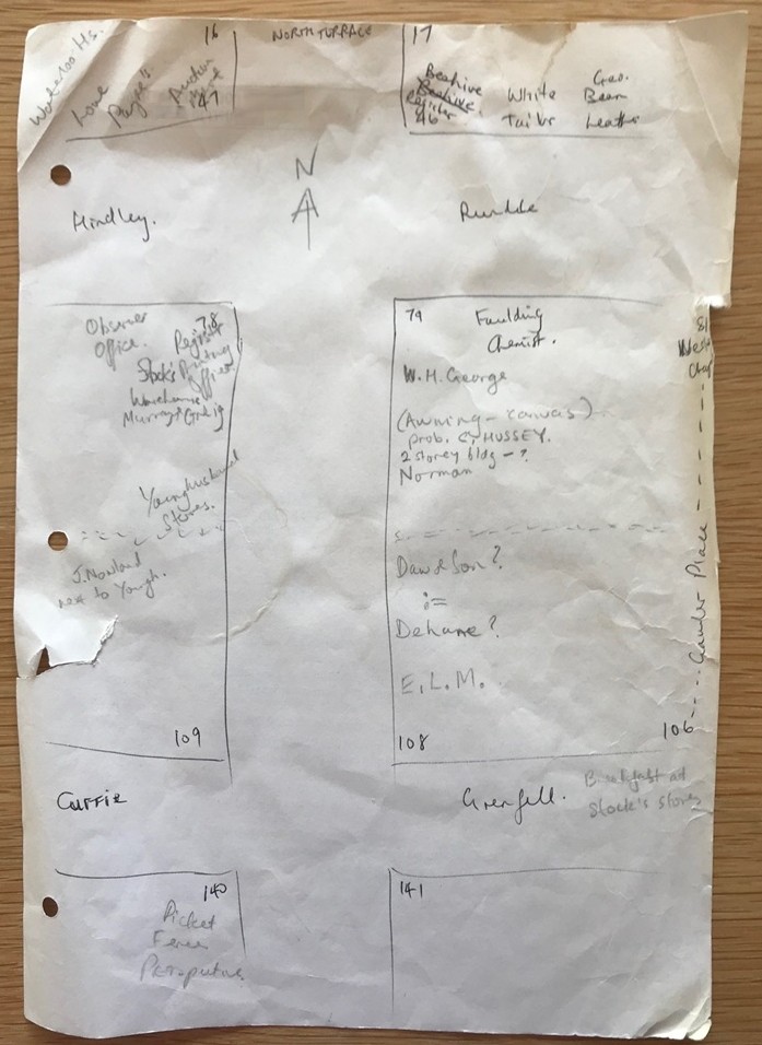
The scrap paper artifact! (author's photograph)
AltText: Tattered A4 sheet with pen and pencil annotations of buildings showing King William Street and intersections with Hindley/Rundle and Currie/Grenfell Streets. Also with Adelaide acre numbers.
I started mapping in 2017 on scrap paper with Gill's Sturt's Departure pictures.
Then from paper, I began using MapWarper in 2019 and published the Port Adelaide map of Gill works (see below) in 2020.
Many collecting institutions have digitised historical maps. To use an image for online mapping, it needs to be obtained at sufficient resolution and then geo-referenced / geo-located / geo-rectified (these terms are used somewhat interchangeably). Geo-referenced map tiles may then be used for a background in digital mapping.
To get higher resolution map images from the State Library of South Australia (SLSA) collection I used Tim Sherratt's GLAM Workbench – SLSA tile stitching tool.
To geo-rectifying with MapWarper I would:
Similar use could be made of PROV MapWarper.
A second (and my preferred) method is to use AllMaps on IIIF images – a method which doesn't involve downloading and re-uploading.
I thank Tim Sherratt (a.k.a. "wragge", site: timsherratt.au) for getting me wise to this through his 2025 Creative Technologist-in-Residence at SLV; see: Georeferencing maps from the State Library of Victoria.
After geo-rectifying the SLV map in AllMaps, I exported the map tiles reference and made this the custom background in uMap.
I used this method for the first time with the map S. T. Gill - Victorian Diggings (below).
The interactive online maps are created using OpenStreetMap's uMap platform. (Help is available in uMap/Guide.)
Most, but not all maps, show a historical map as the default custom background.
 On ABC Radio Adelaide | May 2021
My Adelaide map got noticed and in May 2021 I was interviewed on ABC Radio Adelaide. ABC Adelaide : Interactive, 'street-level view' brings colonial Adelaide to life
It isn't quite Google 'street view', but for an interactive look at what Adelaide was like in the 1840s, a newly released online map offers a close alternative. Created by retired systems developer David Coombe, the map draws predominantly from the paintings of colonial artist Samuel Thomas (S.T.) Gill.
This project uses two types of interactive online maps:
In artwork maps, each work's marker has descriptive text and an image where available. Art work images are not stored but are dynamically displayed from the online services of the collecting institution. Links are provided to each artwork in the collecting institution's catalogue system and/or a web page in this project. The viewpoint includes where possible a view bearing (in degrees; 0 being north, 180 being south, etc).
Artwork map markers are generated from my database. The accompanying text should be basically the same as the corresponding web page article, though the catalogue entry may have more information.
You can't change the map content, but you can change your view by browsing and filtering the data, hiding data layers, and changing the map background. With Browse data | Filter you can find content by subject, title, description or owner. For eaxmple, filtering by "ch" shows chapels, churches and schools. You can filter by holding institution such as AGSA, SLSA, NLA or SLNSW. You can select any of several uMap backgrounds (such as the contemporary OpenStreetMap), and also revert to the default historical map background (usually at the end of the list).
There are more than 250 artworks represented in these maps. To find a specific picture you can use the context map S. T. Gill - Works Mapped or search artwork titles in the index of mapped works. Catalogue pages also contain links to map entries.
These maps rely on the availability of many external services. You can check the availability of external online image and map services used in this project.
Availability: Available online
Status: Complete
The Light/Gliddon map published in 1837. It is the earliest published map of Adelaide and its individual acres and includes the names of the original purchasers. Digitised map image from NLA.
Web page: ../1840s_South_Australia/1837_Adelaide_Map_Original_Purchasers.htm.
Availability: Available online
Status: Complete
The Kingston map represents colonial Adelaide at the beginning of 1842. This map is useful for identifying contemporary buildings and landmarks. References from this map are used as pins in my map: S.T. Gill - Adelaide. Digitised map image from NLA.
Web page: ../1840s_South_Australia/1842_Kingston_Map.htm.
Availability: Available online
Status: Complete
This map is somewhat imprecise but is useful for identifying contemporary buildings and landmarks. References from this map are used as pins in my map: S.T. Gill - Adelaide. Digitised map image from SLSA.
Availability: Available online
Status: Under development
This is a single cluster map showing all artworks in the project.
Pins represent the viewpoint of each work.
Availability: Available online
Status: Complete
This map of South Australia is a context map with links to zoom in to more detailed maps. It also shows other S.T. Gill paintings not covered by more detailed maps.
Availability: Available online
Status: Complete
This map shows S.T. Gill's paintings in south eastern South Australia. By surveyor F.H. Burslem the March 1847 lithograph is "a plan of the settled portion of the colony, shewing the position of all the special surveys".
Availability: Available online
Status: Complete
This map of the District of Adelaide contains links to more detailed maps and shows paintings by S.T. Gill and select paintings by other artists that are not covered by those maps. Digitised map image from NLA.
Availability: Available online
Status: Complete
This map shows S.T. Gill's paintings of Adelaide along with select contemporary pictures by other artists. It includes pins of features from the 1842 Kingston and 1849 Penman maps of Adelaide. Digitised map image from SLNSW.
Availability: Available online
Status: Complete
This map shows S.T. Gill's paintings of Port Adelaide along with select contemporary pictures by other artists. Digitised map image from SLSA.
Web page: ../1840s_South_Australia/S_T_Gill_and_Port_Adelaide.htm.
Availability: Available online
Status: Complete
This map and accompanying article adds to our historical understanding of S.T. Gill's pictures of Prospect House of December 1849 and (likely early) 1850.
Web page: S_T_Gill_and_Prospect_House.htm.
Availability: Available online
Status: Complete
This map shows S.T. Gill's paintings of the the 1846 Horrocks expedition, the route taken and diary entries.
Web page: S_T_Gill's_Horrocks_Expedition_Pictures_1846_1847.htm.
Availability: Available online
Status: Complete
This map locates select pictures connected to E.C. Frome's expedition in July and August 1843.
Availability: Available online
Status: Complete
The map locates select pictures connected to S.T. Gill and Sturt's book "Narrative of an Expedition ...". The background map image is also from the book.
Web page: S_T_Gill_and_Sturt's_Narrative.htm.
Availability: Available online
Status: Complete
This map shows S.T. Gill's paintings of Burra Burra Mine and Township (Kooringa).
Web page: S_T_Gill_and_Burra_Burra_Mine_1847.htm.
Availability: Available online
Status: Complete
This map shows the route(s) from Melbourne to the Victorian diggings and S. T. Gill's 1852 views on this route.
Web page: S_T_Gill_Contents_Victorian_Diggings.htm.
Availability: Available online
Status: Complete
This map shows S. T. Gill's views of the Victorian diggings in 1852. Most works are of a general nature, but those that can be reasonably mapped are included.
Web page: S_T_Gill_Contents_Victorian_Diggings.htm.
David Coombe, May 2021. Updated 11 July 2026. | text copyright (except where indicated).
CITE THIS: David Coombe, 2021-2026, S.T. Gill in Maps, accessed dd mmm yyyy, <https://coombe.id.au/S_T_Gill/S_T_Gill_in_Maps.htm>
 Click to zoom.